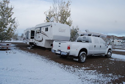
You are correct, SNOW!!!! Our plan was to avoid this kind of weather but the past two days it has snowed. When the sun comes out, everything melts pretty quickly but it is still very cold . . . Brrrr. We are out of here tomorrow; hopefully heading to warmer temperatures.
Thursday, October 29, 2009
Monday, October 26, 2009
Monument Valley, Mexican Hat, and geocaching
After a day off to get some domestics done, today we headed off towards Monument Valley. Monument Valley is famous for being the setting for more Western films than any other site in the United States. It is also the home to the Navajo Indian Nation. Movie tidbit - we wanted to get the shot of the valley where Forrest Gump stopped his cross crountry run. There were a number of us stopping along the road taking shots. This has got to be one of the most beautiful road vistas we have ever seen. The camera just doesn't do the view justice.
 The Visitor's Center was being remodeled so we went up to the Trading Post/Restaurant to browse around and were greeted with some impressive views. Here is West Mitten (left), East Mitten (background), and Merrick Butte.
 Admission to Monument Valley is $5 per person and it does entitle you to take a loop drive through the base valley. Tours led by the Navajo Nation are $80 for a 4-hour tour and $115 for an 8-hour tour that supposedly taked you to areas that aren't readily seen in Monument Valley and/or Mystery Valley. Before we left home, we weren't sure we wanted to spend that kind of money before we had even seen Monument Valley to see if it would be worth a tour. We happily opted to take the drive. Should we return to this area, we would seriously consider taking a tour from what we were able to see on the short drive.
Three Sisters
 After driving the loop, we were hungry and decided to eat at their restaurant. Surprisingly, it was a good choice. The guys had the Green Chili Stew which included chips and salsa, salad, and fry bread. Rick and John both thought the Green Chili Stew was very tasty. I opted for a salad with chicken that had wonderful greens (no iceberg lettuce - yea!). A little skimpy on the chicken but it was still yummy. Y had a patty melt with fries.
 Then we were off with a stop to take a shot of Mexican Hat.
 There was a geocache at the base of Mexican Hat so we stopped to see if it could be located. Checking out the rocky surrounding (snakes???), Y and I decided to stay behind and let the guys go with a walking stick to poke around any possible sites. That's Y and I standing way in the back near the Jeep. Success! John and Rick located the cache - Rick with the bounty.
 There was another geocache to be found back up the road, so we stopped to try our luck. Yep, another one found. Here's John holding the container.
 Off to our next viewing pleasure.
Goosenecks State Park - UT
Goosenecks State Park is just north of Mexican Hat. You look 1,000 feet down to see the San Juan River flow back and forth for more than five miles as it heads to the Colorado River and Lake Powell. The picture below is just one section of how the river meanders.
 Another section.
 A shot of the San Juan River.
 The views were fabulous - that is all there is to see at this state park.
We ended our sightseeing day by going over to Rick and Y's for an evening of cards.
Saturday, October 24, 2009
Hovenweep National Monument - UT/CO Border
After Four Corners, our next stop was Hovenweep National Monument. A Morman expedition led by W.D. Huntington discovered the abandoned remains of a civilization in 1854. Hovenweep is the Ute word for deserted valley and was adopted by pioneer photographer William Henry Jackson in 1874. In 1923, President Harding declared Hovenweep a unit of the National Park System.
 After watching a movie at the Visitor's Center and before taking the hike around Square Tower Group, we decided it was time for lunch. As we ate lunch outside at a picnic table, we were visited by the very assuming Scrub Jay that we would give him a handout. John put a walnut out at the end of the table and in he flew and picked up the nut and flew off. This was to be repeated numerous times. We even got to watch him bury one of the nuts near where we were sitting. That was interesting. I wonder how he will find his treasures later on.
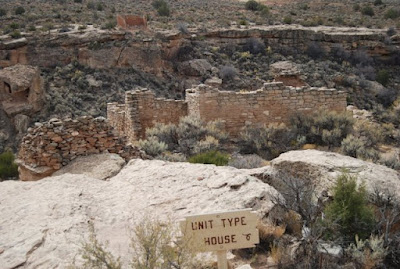
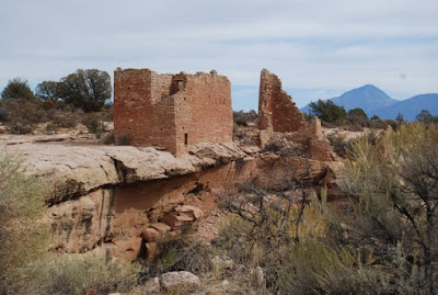
 The towers of Hovenweep were built by Ancestral Puebloans between A.D. 1200 to A.D. 1300. The buildings are of various size and shape. The masonry is skillful and beautiful. We marveled at how they rounded edges and made square cuts to the rocks. How did they do that? What is even more amazing, is that after 700 years so much of the buildings are still standing. We took the hike around Square Tower Group as it has the most structures in a defined area.
 Archaeologists have found most of the towers were associated with kivas (Puebloan ceremonial structures - usually circular) but their true purpose remains a mystery. Were they defensive in nature, celestrial observatories, storage facilities, or simply fancy homes? No one knows.
By the end of the 13th century, the area was vacated. Why, no one really knows but there is a lot of speculation: drought, lack of food, warfare. What they do know is that Ancestral Puebloans migrated south to the Rio Grande Valley in New Mexico and the Little Colorado Basin in Arizona. Zuni, Hopi, and Pueblo Indians are descendants of this culture.
Here we were in the middle of nowhere and yet there remains proof that at one time, this area was alive with farming, families, and social networks. Makes you wonder what this area looked like way back then - maybe it was a green oasis a stark contrast to the desert it is today.
Four Corners - UT, CO, NM, AZ
We have heard about Four Corners where the borders of Utah, New Mexico, Colorado, and Arizona meet for years. As we may never be as close to visit the area as we are now, we decided it was a must see. Rick and Y had visited the area many years ago and warned us that it was in the middle of nowhere and there wasn't much to see other than the monument. Boy, they certainly were correct about it being out in the middle of nowhere. Still, it was well worth taking the drive to see Four Corners for ourselves.
Here is a picture of the four of us - one of us each standing in a different state.
 Me with four different body parts in four different states.
 John enjoying himself in four states at once.
Friday, October 23, 2009
Bluff Fort Historic Site - Bluff, UT
After a warm welcome at the Visitor's Center, we sat down to watch a movie about the Hole in the Rock/San Juan Mission pioneers. Mormon pioneers who received the assignment call to establish communities in southwestern Utah and the Four Corners area left Escalante, UT in 1879 and arrived in the San Juan River area in 1880. Their journey had them endure unbelievable difficulties as they blazed a trail across some of the most rugged terrain imaginable. Their path included a journey through a crevice through the Colorado River gorge now called Hole in the Rock. After crossing the Colorado River, they had to forge a path up Cottonwood Canyon and then San Juan Hill. Seven horses or oxen teams had to be hitched together with men pushing each wheel to pull each of the heavy wagons to the top. Can you imagine? It certainly left me feeling very impressed with the sacrifices, toughness and commitment to faith each pioneer showed during their journey. The average age of the pioneers was 17 and amazingly, not one life was lost during their six-month journey.
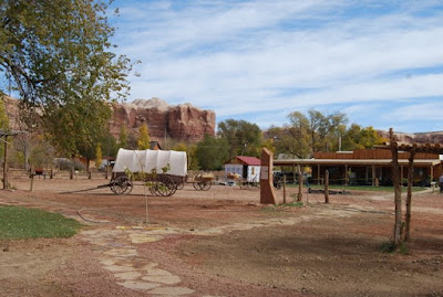
When the pioneers finally arrived and settled what is now the town of Bluff, they built one-room log cabins that were arranged to form a large square. Their assignment was to "feed the Indians; not fight them". Descendants of these pioneers have formed an organization to preserve and restore the original fort site. Volunteers were busily working putting the final touches on the premises today as they were getting ready for an unveiling of a statue and dedication on Saturday. We walked around the fort and while they still have a lot of work ahead of them, we got a good glimpse of pioneer life:
When the pioneers finally arrived and settled what is now the town of Bluff, they built one-room log cabins that were arranged to form a large square. Their assignment was to "feed the Indians; not fight them". Descendants of these pioneers have formed an organization to preserve and restore the original fort site. Volunteers were busily working putting the final touches on the premises today as they were getting ready for an unveiling of a statue and dedication on Saturday. We walked around the fort and while they still have a lot of work ahead of them, we got a good glimpse of pioneer life:
Navajo Hogan
 The area around here is remote to this day. To think of it in 1880 when the Mormon pioneers arrived leaves me impressed with their dedication and conviction to establish a home in these barren lands. The quote of one the pioneers, Jens Nielsen, "If we have plenty of stick-ta-tudy, we cannot fail" and they didn't.
Thursday, October 22, 2009
Bluff, Utah
We left Moab a little after 10 a.m. and pulled into Cottonwood RV Park in Bluff, Utah a little before noon (roughly 100 miles). We are going to use Bluff as a base of operations for seeing the numerous sights in the southeastern corner of the state (better known as four corners). This park is truly big rig friendly with long, wide sites and very quiet. Our two rigs' front doors face one another so we have a nice private common area.
 The cottonwoods are in their fall color and add a special beauty to the surrounding red-walled canyons.
Wednesday, October 21, 2009
Islands in the Sky - Canyonlands National Park
After two days off to basically chill and a day of off due to rain, we decided to visit Canyonlands NP as our time here in Moab was quickly coming to a close.
Canyonlands is divided into three sections: Needles, Maze, and Islands in the Sky. The section closest to us here in Moab was Islands in the Sky. I would have to say this section was aptly named as the following pictures will show. With the valley receiving rain, the higher elevations of the LaSal Mountains received snow and provided a beautiful backdrop to Canyonlands.
 John and I are sitting in front of Mesa Arch. The views from this area were spectacular and well worth the hike to the arch. The arch itself looked like it was barely attached to the canyon wall which was an illusion, I'm sure. I don't think too many people would consider walking on top of this arch as there is nothing but a free fall into the canyon should you slip.
There is so much to see and do in the Moab area. This area will definitely be put on our must visit again list as we have enjoyed our time here and would look forward to returning.
Saturday, October 17, 2009
Hole n' the Rock & Moab Museum of Film and Western Heritage
We visited the attraction Hole N' The Rock that is located 12 miles south of Moab. Basically, this is a 5,000 square home and gift shop built into solid sandstone rock by Albert and Gladys Christensen. There are 14 rooms separated by large pillars inside where the temperature stays a constant 69 to 72 degrees year round. Unfortunately, they wouldn't let us take interior pictures so if you would like to see more about this attraction, click here.
 Albert died in 1957 and even though he had evacuated 50,000 feet of sandstone from the rock, the house was not finished. Gladys continued on with Albert's dream and wishes to develop the home for all to see. When Gladys passed away in 1974, she was laid to rest next to Albert in a simple rock alcove on the property. In 2000, the son sold the property to an investment company who now runs the attraction.
The grounds are rather eclectic as the following pictures will show:
Large lizard welcomes you
 After stopping for lunch in Moab, we then headed off to the beautiful Red Cliff Lodge. The Red Cliff Lodge sits alongside the Colorado River in a beautiful valley of nothing but red rocks. The Red Cliff Lodge is also a working ranch and houses the Moab Museum of Film and Western Heritage. Since the late 40's, the Moab area has been the site of filming for many westerns, TV shows, movies, and commercials. The museum was free (a nice thing) and was interesting to learns about the movies that have been filmed in the area.
 Here is a nice shot of the Colorado River as we head back towards Moab. We saw some rafters and kayakers enjoying themselves on this beautiful day on the river.
Subscribe to:
Comments (Atom)


